By Robert Frank
www.thesuburban.com
Homes, schools, hospitals and highway overpasses are more at-risk than most people realize, should an earthquake strike Montreal.
In all of Canada, only Vancouver faces a greater seismic risk than the Montreal region.
Some buildings here sit on soil that amplifies those shock waves like jelly, Canadian Seismic Research Network (CSRN) researchers have discovered. Those extensive clay and sandy soil deposits in certain parts of Montreal compound that problem. Some of those deposits are deep, reaching dozens of metres below the surface of the ground.
The result? Buildings there shake back and forth more during a tremblor.
That’s important. According to University of Western Ontario Prof. Gail Atkinson, how much the earthquake will rock your home ultimately matters more than how strong the earthquake is.
“Deep, soft soils tend to amplify ground motions,” she explained in a CBRN video. “We take into account how much ground motion we expect and how it’s amplified by the local soil.”
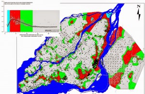
Years of testing by a team led by McGill Engineering Prof. Luc Chouinard have helped to pinpoint the Montreal’s most earthquake-sensitive areas.
It highlighted that the Port of Montreal, Old Montreal and a small part of the downtown core lie where some of the numerous elevated seismic risk zones are found, as well as Notre Dame de Grâce and the former CN Turcot yard, as does Pointe aux Trembles, which is named for its earthquake-prone past.
On the West Island, much of Kirkland, Dorval and Senneville also face elevated risk, as are some spots along the shore of Lac St. Louis. In contrast, most of Dollard des Ormeaux appears to be built upon solid ground.
In Laval, the entire eastern tip of Île Jésus is affected, as is the easternmost part of Val des Brises. Parts of western Chomedey north of Samson also sit on softer soil. So does the Rivière des Prairies shoreline surrounding Highway 13 as well as in Abord à Plouffe.
A moderate earthquake centered within, say, 50 km of Montreal could cause significant destruction, because Quebec’s typically solid bedrock transmits the shock waves much farther than on the West Coast.
“An earthquake of the same size is felt over a much larger area and causes more damage in Eastern Canada,” said Prof. Atkinson. “In the West, earthquakes are 10 times as frequent.”
Here, she said, the shock waves travel 10 times as far, without weakening much.
“By the time that you get 200-300 km away from the epicentre,” she said, “motions in the east caused by an earthquake of the same magnitude at its origin can be higher than in Western Canada by a factor of 10.”
“Something like a magnitude 6 earthquake happening within 30 km of [the] Montreal [region] is not that giant an earthquake, but the kind of earthquake that gives us a two percent probability over 50 years of happening in Montreal,” Prof. Atkinson told the audience.
Some schools, hospitals vulnerable
Prof. Chouinard told The Suburban that he and his collaborators have been sharing their findings with city public safety officials.
He said in an interview that his data is used to assess which schools, hospitals and so forth might need an upgrade, to mitigate the risk.
“Sometimes there is an opportunity for structural strengthening,” he explained. “It is not something that is necessarily systematic. We’ve been looking at older buildings doing retrofits on a case-by-case basis, depending if you have a structure identified as being essential, for example hospitals or schools.”
It’s a Herculean task, given the number of such institutions in Quebec.
According to University of Quebec graduate student Mohammed Mestar, very little has been done to mitigate earthquake risk in Quebec’s public buildings to date.
In an engineering study that he published April 1, he observed that the province has no systematic, large-scale vulnerability-assessment program.
“The seismic vulnerability assessment of buildings is based on collecting information by inspection and studying plans,” Mestar wrote. “This approach is however not practical for the evaluation of a large sample, such as Quebec’s 2,714 school buildings.”


